Home › Forums › General › General Board › pipeline inspection
- This topic has 9 replies, 4 voices, and was last updated 12 years, 6 months ago by
LukeD.
-
AuthorPosts
-
January 5, 2012 at 11:36 am #4783
Joze Saje
ParticipantHello!
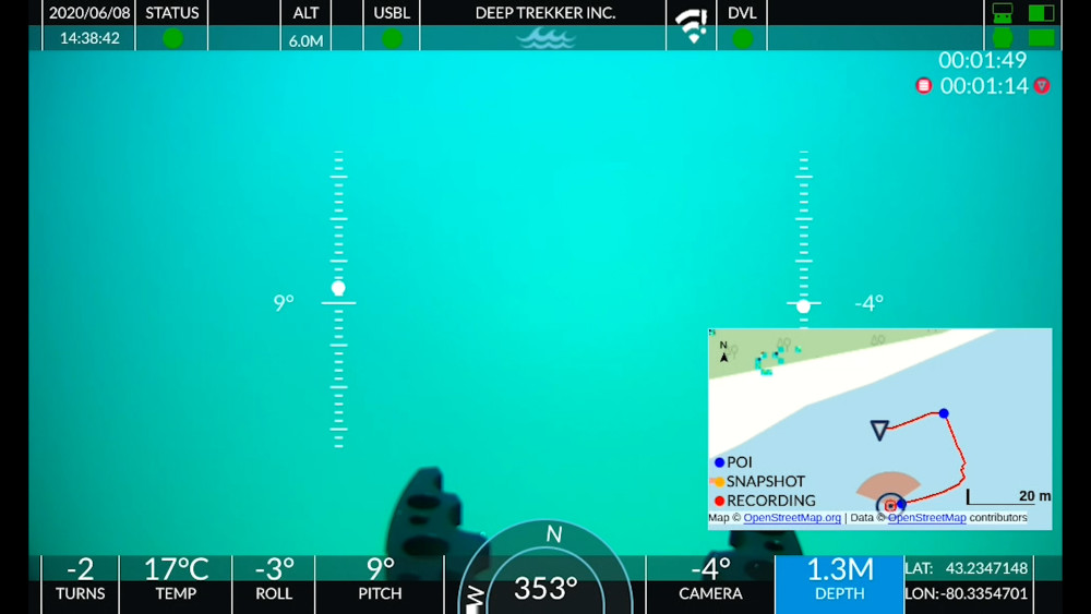
We made ROV ( 300 m depth rating) and now want to see if there is a posibility to get some job in that area. At this moment, ROV has basic setup like camera, lights, simple graber, depth and heading sensor, auto-depth holding,… My question is, which system should we add to ROV that can do pipeline survey? Which data customers wants to have in Report when order pipeline inspection. Thank you in advance for answer. Best regards, Joze[/img]
rov_992.jpg  January 5, 2012 at 6:05 pm #31957
Savante
ParticipantI would reccomend that you check out the Teledyne TSS-440. This is a routine sensor requirement for pipeline surveys.
Best Regards,
Grant
January 7, 2012 at 10:03 am #31958ParticipantThank you Grant,
maybe you or someone can suggest me some agencys site where are colected tenders to see where to get observation job or later pipeline inspections.
thx, JozeJanuary 12, 2012 at 8:32 am #31959Raymond
ParticipantTheTSS440 will only be required if there is some possibilbity that the pipe is buried, which it probably will be if you only work in max 300m.
Other ROV sensors you will need include a Bathy system Tritech seem to be accepted as a standard for this, dual head profiling sonars; Doppler; motion sensor; Ring laser or fibre optic gyro. you may also requre port, centre and starboard cameras to inspect all sides of the pipe.
At the topside you would need a navigation software package, EIVA NaviPac is a world leader; it will also allow you to event the survey and collate all the ROV sensor data for final reporting.
Part of the final report will have to be integrated video footage, for this you will need a digital video recorder, the EIVA software integrates easily to the NETmc Marine X-Ops DVR, allowing simultaneous recording of up to four channels of video and their replay with the survey data.
if you want any further info send me a PM.
regarding tenders, try the European Journal.
Regards
RaymondFebruary 21, 2012 at 8:51 am #31960Participanthow is made calibration with TSS pipe tracker at start?
Do you need to know exact depth of buried pipe at start that you can make calibration of TSS ?February 21, 2012 at 10:05 am #31961ParticipantIt is s few years since i used a system but i believe you have to put in the diameter of the target, input if there is a weight coating then move the ROV off to the side of the pipe, far enough away from the target not to "see" its magnetic field, then perform a back ground compensation; this records the earth;s field and the ROV’s signature so that when you go back to the target it shows up as a discontinuity.
But this procedure may have changed so best thing to do is contact TSS and ask them to send you a pdf of the manual. NOTE; Calibration procedures may change depending on the client’s requirement and the target to be tracked.
February 21, 2012 at 9:08 pm #31962ParticipantI am asking because some guys here developed proton type magnetometer and thinkinng about to modifie it and adjust to use with ROV for pipetracking. Maybe there is also market demands …
February 21, 2012 at 9:55 pm #31963Participantproton maggys have been used as pipeline detectors in non ROV survey operations for many years, i don’t know enough about them but your guys need to consider signal saturation, range to target has to be at least 5m, background cancelling and being able to triangulate to the top of the pipe as this is the info the client wants.
I think the survey proton maggys are normally used as a towed unit, but they normally have to towed quite far behind the vessel so that it’s own magnetic field is not "seen" by the unit.
I assume this system would be passive, this causes problems when tracking a pipe as it’s magnetic field can vary a lot over it’s length, the TSS style induction system is an semi-active system in that it induces a signal into the pipe, thus giving more stable tracking ability. Measurements with the TSS system is only managed through using three TX/RX coils, thus ambiguity of position is reduced and a vertical range can be calculated.
have you done any trials with your proton device?
February 22, 2012 at 1:57 pm #31964Participantyes, here is 3d plot when scaning larger area with buried test targets.
PPM can also be connected with GPS device.
[/img]3d_plot_138.jpg  February 22, 2012 at 7:58 pm #31965
LukeD
ParticipantAnd then there is the Vehicle itself , Metal plus wiggleys of the Power to the sub .
-
AuthorPosts
- You must be logged in to reply to this topic.